Send me your bug reports, suggestions and pull requests.
Please feel free to use this library in your plugin. Standardization makes life easier for everyone. If this plugin isn't meeting your needs, or you have other great ideas, lets talk!
There are two main classes: WP_GeoQuery and WP_GeoMeta
WP_GeoMeta— Handles adding, updating and deleting spatial values.WP_GeoQuery— Handles spatial meta queries.
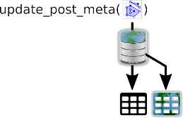
When a user runs add_post_meta (etc.) and passes in a GeoJSON string or GeoJSON compatible array, WP_GeoMeta will store the geometry in a spatial column.
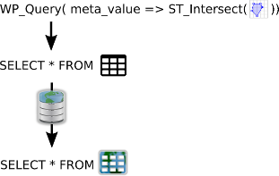
WP_GeoQuery sets up a handler for the get_meta_sql action to spatial queries and orderby operations.
An additional class WP_GeoUtil handles data checking and conversion.
WP_GeoMeta builds on both MySQL's spatial support and the WordPress meta data system.
On plugin activation WP-GeoMeta will create a parallel spatial set of meta tables. Where only wp_postmeta existed you will now also find wp_postmeta_geo.
WP-GeoMeta uses the actions (added|updated|delete)_(comment|post|term|user)_meta to
do the right thing AFTER add_post_meta (etc.) have done their jobs.
$single_feature = '{
				"type": "Feature",
				"geometry": {
					"type": "Point",
					"coordinates": [-93.5, 45]
				},
				"properties": {
					"prop0": "value0"
				}
}';
update_post_meta(48,'my_shape',$single_feature);
Since GeoJSON is the one true format for spatial data on the web, all getting and setting of spatial data is done in this format. Someone could add a plugin to support other formats though!
FeatureClass objects and individual Feature objects will both be accepted. String object and array representations of GeoJSON are be accepted.
WP-GeoMeta stores data in EPSG:4326 by default, which is (a) the official format for GeoJSON and (b) the most common format for web maps.
WP-GeoMeta does't act on any of the get_{$meta_type}_meta filters because we want the
orignal input data to be returned to the user with the GeoJSON properties it had at the
beginning.
WP_GeoQuery adds support to the meta_query argument (in WP_Query, get_posts, WP_User_Query, get_users, WP_Comment_Query and get_comments) for known spatial comparison operations.
It uses the get_meta_sql action to inspect and modify the query, re-routing the spatial portions of the query to the wp_postmeta_geo table.
This is the most fragile part of WP-GeoMeta-Lib, for now. It looks through the meta_query definition and generates replacement INNER JOIN and WHERE
clauses. It then uses str_replace to alter the original SQL.
See the USAGE.md for examples of how to use WP_GeoQuery.

